 |
 © ©
|  |
 |
| Vessel Type: | White Star Liner | Location: | Co. Donegal |
| Date of Loss: | 19th July 1918 | Place: | Innistrahull |
| Cause of Loss: | Torpedoed | Boat Dive from: | Culdaff |
| Charted Depth: | 70m | Irish O.S. Map: | Discovery Series No. 3 |
| Height of Wreck: | 10m | Admiralty Chart No: | 2811 and/or 2723 |
| Hull Material: | Steel | Latitude (GPS): | 55° 39' 27.60" North |
| Type of Seabed: | Rock & kelp | Longitude (GPS): | 07° 43' 07.20" West |
| Average Visibility: | 20 - 30m | Convert Lat. & Long. to - | Decimal - CLICK HERE |
| Image available? | Yes - see below | Diving Experience: | Very Experienced Tri-Mix |
| Diving Information: |
|
| Historical Information: |
|
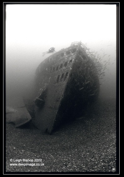
© by kind permission of Leigh Bishop web site
Click
HERE
for INFOMAR*
Side-Scan image |
| Source Publications: |
| "Dive"
Magazine - article |
by | Rich Stevenson (March 2001) |
|
"Donegal
Shipwrecks" |
by | Ian Wilson |
| Impact Printing 1998 - ISBN: 094815456X | ||
"Scuba"
Magazine article | by | Darren McDonagh (November 2016) |
|
"Shipwreck
Index of Ireland" |
by | Richard & Bridget Larn |
| Lloyd's Register - Fairplay Ltd 2002 - ISBN: 1900839970 | ||
|
"Shipwrecks
of the Irish Coast 932 - 1997" |
by | Dr. Edward J. Bourke |
| Edward J. Bourke 1998 - ISBN: 0952302713 |
| Other Sources: |
*Geological
Survey of Ireland | Internet (2020) | |
| Edgar
Scott | - | Email 2001 |
| Leigh
Bishop's www.deepimage.co.uk
| - | Internet (2004) |
| |
Last update - 08-Nov-2020
|
|
A page from "www.irishwrecksonline.net" ©