 |
 © ©
|  |
 |
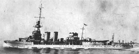
| Vessel Type: | Light Cruiser | Location: | Co. Donegal |
| Date of Loss: | 18th February 1917 | Place: | 20 miles North West of Bloody Foreland |
| Cause of Loss: | Cut in two by S.S. Queen Mary | Last known position: | 55° 22' North x 08° 44' West |
|
© by kind permission of Jan Lettens wrecksite.eu web site
© Geological Survey of Ireland | ||
| Source Publications: |
| "Irish
Wrecks Database" | by | Roy Stokes & Liam Dowling | |
|
"Shipwreck
Index of Ireland" | by | Richard & Bridget Larn | |
| Lloyd's Register - Fairplay Ltd 2002 - ISBN: 1900839970 | |||
| |
Last update - 08-Nov-2020
|
|
A page from "www.irishwrecksonline.net" ©