 |
 © ©
|  |
 |
| Vessel Type: | Steam Collier | Location: | Co. Donegal |
| Date of Loss: | 4th March 1918 | Place: | Innistrahull |
| Cause of Loss: | Torpedoed | Boat Dive from: | Culdaff |
| Charted Depth: | 33m | Irish O.S. Map: | Discovery Series No. 3 |
| Height of Wreck: | 3m | Admiralty Chart No: | 2811 |
| Hull Material: | Steel | Latitude (approx.): | 55° 19' 12" North* |
| Type of Seabed: | Course gravel | Longitude (approx.): | 07° 03' 36" West* |
| Average Visibility: | 15m + | Convert Lat. & Long. to - | Decimal - CLICK HERE |
| Image available? | Yes - see below | Diving Experience: | Experienced |
| Diving Information: |
|
Historical Information: |
|
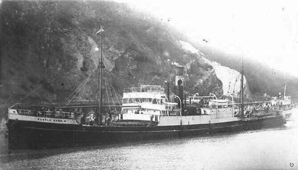
© by kind permission of photoship web site
Source
Publications:
|
| "Donegal
Shipwrecks" |
by | Ian Wilson |
| Impact Printing 1998 - ISBN: 094815456X | ||
| "Shipwreck
Index of Ireland" |
by | Richard & Bridget Larn |
| Lloyd's Register - Fairplay Ltd 2002 - ISBN: 1900839970 | ||
| "Shipwrecks
of the Irish Coast 932 - 1997" |
by | Dr. Edward J. Bourke |
| Edward J. Bourke 1998 - ISBN: 0952302713 | ||
| "Shipwrecks of the Irish Coast 1105 – 1993" |
by | Dr. Edward J. Bourke |
| Edward J. Bourke 1994 - ISBN: 0952302705 | ||
| "Underwater
Ireland Guide to Irish Dive Sites" |
by | Irish Underwater Council |
| CFT 1999 - ISBN: 0948283025 |
Other
sources: |
*source
- Geological Survey of Ireland | - | Internet (2020) |
| Royal
Navy | - | Hydrographic Department (1970) |
| |
Last update - 02-Nov-2020
| |
A page from "www.irishwrecksonline.net" ©