 |
 © ©
|  |
 |
| Vessel Type: | R.N. Tug | Location: | Co. Donegal |
| Date of Loss: | 18th October 1941 | Place: | Bluick Rock, Greencastle |
| Cause of Loss: | Ran aground | Boat Dive from: | |
| Charted Depth: | Irish O.S. Map: | Discovery Series No. 3 & 4 | |
| Height of Wreck: | Admiralty Chart No: | 2499 | |
| Hull Material: | Steel | Latitude (approx.): | 55° 13' 00" North |
| Type of Seabed: | Longitude (approx.): | 06° 56' 12" West | |
| Average Visibility: | Convert Lat. & Long. to - | Decimal - CLICK HERE | |
| Image available? | Yes - see below | Diving Experience: |
| Diving Information: |
|
Historical Information: |
|
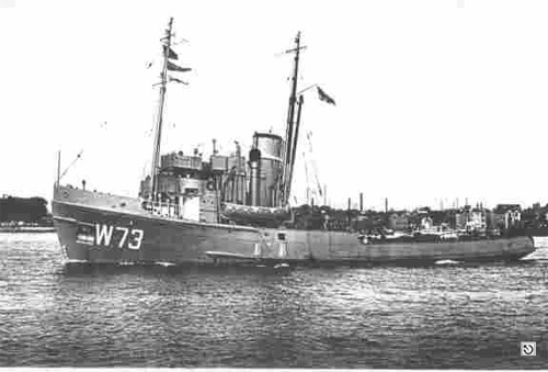
Photo of "H.M.S. Prudence" - the same class as "H.M.S. Assurance"
© by kind permission of Peter Brendt
Source Publications: |
|
"Shipwreck
Index of Ireland" | by | Richard & Bridget Larn |
| Lloyd's Register - Fairplay Ltd 2002 - ISBN: 1900839970 | ||
| "Shipwrecks
of the Irish Coast 932 - 1997" |
by | Dr. Edward J. Bourke |
| Edward J. Bourke 1998 - ISBN: 0952302713 | ||
|
"Shipwrecks
of the Irish Coast 1105 – 1993" |
by | Dr. Edward J. Bourke |
| Edward J. Bourke 1994 - ISBN: 0952302705 |
| Other Sources: |
| Internet 2006 |
| |
Last update - 11-Dec-2006
|
|
A page from "www.irishwrecksonline.net" ©