 |
 © ©
|  |
 |
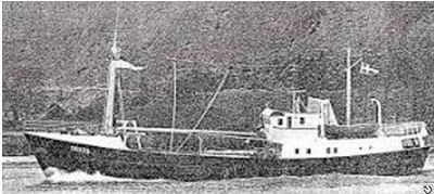
| Vessel Type: | Heavy Trawler | Location: | Co. Donegal |
| Date of Loss: | 31st October 1981 | Place: | Burtonport |
| Cause of Loss: | Struck rocks | Boat Dive from: | Burtonport Harbour |
| Charted Depth: | 28m | Irish O.S. Map: | Discovery Series No. 1 |
| Height of Wreck: | 4m | Admiralty Chart No: | 1883 and/or 2792 |
| Hull Material: | Steel | Latitude (GPS): | 55° 56' 24.72" North |
| Type of Seabed: | Sand and rocks | Longitude (GPS): | 08° 38' 30.48" West |
| Average Visibility: | 10 - 15m | Convert Lat. & Long. to - | Decimal - CLICK HERE |
| Image available? | Yes - see below | Diving Experience: | Experienced |
| Diving Information: |
|
| Historical Information: |
|
© by kind permission of wrecksite.eu web site
| Source Publications: |
| "Dive
Sites" | by | Ivor McCaw |
| NIFSAC "Viz" Magazine (1988) | ||
| "Shipwreck
Index of Ireland" |
by | Richard & Bridget Larn |
| Lloyd's Register - Fairplay Ltd 2002 - ISBN: 1900839970 | ||
| "Shipwrecks
of the Irish Coast 932 - 1997" |
by | Dr. Edward J. Bourke |
| Edward J. Bourke 1998 - ISBN: 0952302713 | ||
|
"Underwater
Ireland Guide to Irish Dive Sites" |
by | Irish Underwater Council |
| CFT 1999 - ISBN: 0948283025 |
| Other Sources: |
| Bryan
Johnson | by | via Email (2006) |
| Bill
Quinn | by | via Email (2007) |
| |
Last update - 30-Nov-2007
|
|
A page from "www.irishwrecksonline.net" ©