 |
 © ©
|  |
 |
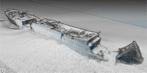
| Vessel Type: | Steam Collier | Location: | Co. Dublin |
| Date of Loss: | 5th June 1917 | Place: | Lambay Island |
| Cause of Loss: | Torpedoed | Boat Dive from: | Howth Harbour |
| Charted Depth: | 36m | Irish O.S. Map: | Discovery Series No. 50 |
| Height of Wreck: | 6m | Admiralty Chart No: | 1468 and/or 44 |
| Hull Material: | Steel | Latitude (approx.): | 53° 33' 02" North |
| Type of Seabed: | Silt | Longitude (approx.): | 05° 55' 03" West |
| Average Visibility: | 6 - 10m | Convert Lat. & Long. to - | Decimal - CLICK HERE |
| Image available? | Yes - see below | Diving Experience: | Experienced |
| Diving Information: |
|
| Historical Information: |
|
© Shipwrecks of World War 1 Revealed - 5th April 2016 - Argunners Magazine
| Source Publications: |
| "Irish
Wrecks Database" | by | Roy Stokes & Liam Dowling |
|
"Shipwreck
Index of Ireland" |
by | Richard & Bridget Larn |
| Lloyd's Register - Fairplay Ltd 2002 - ISBN: 1900839970 | ||
|
"Shipwrecks
of the Irish Coast 932 - 1997" |
by | Dr. Edward J. Bourke |
| Edward J. Bourke 1998 - ISBN: 0952302713 | ||
"Shipwrecks
of the Irish Coast 1105 - 1993" | by | Dr. Edward J. Bourke |
| Edward J. Bourke 1994 - ISBN: 0952302705 | ||
|
"Capital
Diving" Article by James Scallon |
by | SubSea Magazine Summer 2010 |
| ISSN 0791-475X |
| Other Sources: |
| UK
Diving | - | Internet (Chris Troy 1994) |
|
|
Last update - 08-Jul-2020
|
|
A page from "www.irishwrecksonline.net" ©