 |
 © ©
|  |
 |
| Vessel Type: | Motor Coaster | Location: | Co. Antrim |
| Date of Loss: | 7th September 1955 | Place: | The Maidens |
| Cause of Loss: | Struck rocks | Boat Dive from: | Ballylumford |
| Charted Depth: | 16m | Irish O.S. Map: | Discovery Series No. 9 |
| Height of Wreck: | 3m | Admiralty Chart No: | 2198 and/or 2199 |
| Hull Material: | Steel | Latitude (GPS): | 54° 55' 33.48" North |
| Type of Seabed: | Rocks | Longitude (GPS): | 05° 43' 30.9" West |
| Average Visibility: | 8 - 10m | Convert Lat. & Long. to - | Decimal - CLICK HERE |
| Image available? | Yes - see below | Diving Experience: | Experienced Novice |
| Diving Information: |
|
| Historical Information: |
|
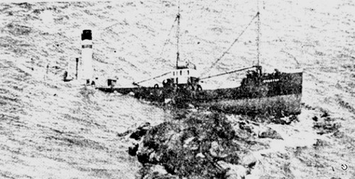
© by kind permission of James Connor via email
All rights respectfully acknowledged
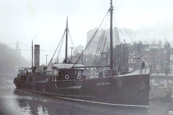
© by kind permission of wrecksite.eu web site
| Source Publications: |
| by | Roy Stokes & Liam Dowling | |
|
"Shipwreck
Index of Ireland" |
by | Richard & Bridget Larn |
| Lloyd's Register - Fairplay Ltd 2002 - ISBN: 1900839970 | ||
|
"Shipwrecks
of the Irish Coast 932 - 1997" |
by | Dr. Edward J. Bourke |
| Edward J. Bourke 1998 - ISBN: 0952302713 | ||
|
"Shipwrecks
of the Ulster Coast" |
by | Ian Wilson |
| Impact Printing 1997 - 0948154993 | ||
|
"Underwater
Ireland Guide to Irish Dive Sites" |
by | Irish Underwater Council |
| CFT 1999 - ISBN: 0948283025 |
Other Sources: |
Royal
Navy | - | Hydrographic Department (1970) |
| Peter
Steel | - | North Irish Lodge, Islandmagee (1999) |
| |
Last update - 04-Apr-2003
|
 |
A page from "www.irishwrecksonline.net" ©