 |
 © ©
|  |
 |
| Vessel Type: | 3 Masted Steamer | Location: | Co. Down |
| Date of Loss: | 31st March 1946 | Place: | Belfast Lough |
| Cause of Loss: | Collision | Boat Dive from: | Bangor or Groomsport |
| Charted Depth: | 30m | Irish O.S. Map: | Discovery Series No. 15 |
| Height of Wreck: | 5m | Admiralty Chart No: | 1753 |
| Hull Material: | Steel | Latitude (GPS): | 54° 43' 56.04" North |
| Type of Seabed: | Sand | Longitude (GPS): | 05° 35' 19.38" West |
| Average Visibility: | 5 - 8m | Convert Lat. & Long. to - | Decimal - CLICK HERE |
| Image available? | Yes - see below | Diving Experience: | Experienced |
| Diving Information: |
|
| Historical Information: |
|
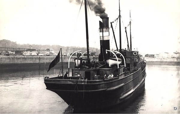
© by kind permission of Michael Montgomery, Castlereagh SAC
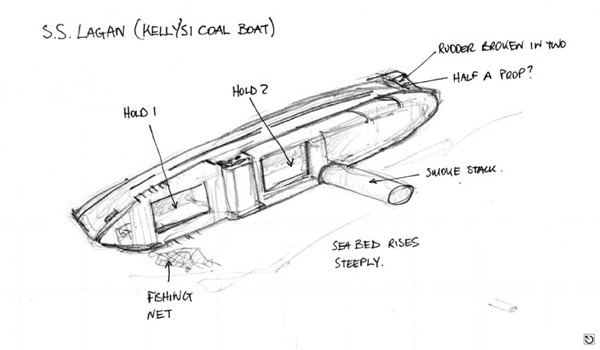
© by kind permission of Michael Montgomery, Castlereagh SAC
| Source Publications: |
| "Irish
Wrecks Database" | by | Roy Stokes & Liam Dowling |
|
"Shipwreck
Index of Ireland" |
by | Richard & Bridget Larn |
| Lloyd's Register - Fairplay Ltd 2002 - ISBN: 1900839970 | ||
| "Shipwrecks
of the Ulster Coast" |
by | Ian Wilson |
| Impact Printing 1997 - ISBN: 0948154993 | ||
| "Underwater
Ireland Guide to Irish Dive Sites" |
by | Irish Underwater Council |
| CFT 1999 - ISBN: 0948283025 |
| Other Sources: |
| Gordon
Leathem B.E.M. | - | From his private notebook (2008) |
| Michael
Montgomery | - | Castlereagh SAC (2006) |
| Michael
Hamilton | - | Castlereagh SAC (1997) |
| Peter
Steel | - | North Irish Lodge, Islandmagee (1999) |
| Vic
Foster | - | Castlereagh SAC (1996) |
| |
Last update - 08-Apr-2008
|
|
A page from "www.irishwrecksonline.net" ©