 |
 © ©
|  |
 |
| Vessel Type: | Liner | Location: | Co. Donegal |
| Date of Loss: | 28th October 1940 | Place: | 50 miles West of Burtonport |
| Cause of Loss: | Bombed, & torpedoed by U-Boat U-32 | Last known position: | 55° 19' 12" North x 09° 40' 48" West* |
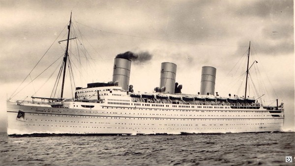
© by kind permission of Ian Coombe of mnnostalgia and the Claude Meldrum Collection
Click
HERE
for INFOMAR* Side-Scan image |
Source
Publications:
|
| "Dictionary of Disasters at Sea during
the Age of Steam 1824
- 1962" |
by | Charles Hocking |
| London Stamp Exchange 1989 - ISBN: 0948130474 | ||
| "Irish
Wrecks Database" | by | Roy Stokes & Liam Dowling |
|
"Shipwreck
Index of Ireland" |
by | Richard & Bridget Larn |
| Lloyd's Register - Fairplay Ltd 2002 - ISBN: 1900839970 |
Other
Sources: |
*source
- Geological Survey of Ireland | - | Internet (2020) |
|
|
Last update - 18-Jul-2020
|
|
A page from "www.irishwrecksonline.net" ©