 |
 © ©
|  |
 |
| Vessel Type: | Steam Yacht | Location: | Co. Antrim |
| Date of Loss: | 1918 approx. | Place: | Cushendun Bay |
| Cause of Loss: | Foundered | Boat Dive from: | Cushendun |
| Charted Depth: | 6m | Irish O.S. Map: | Discovery Series No. 5 & 9 |
| Height of Wreck: | 3m | Admiralty Chart No: | 2199 |
| Hull Material: | Iron | Latitude (approx.): | 55° 07' 47" North |
| Type of Seabed: | Sand | Longitude (approx.): | 06° 02' 15" West |
| Average Visibility: | 5 - 10m | Convert Lat. & Long. to - | Decimal - CLICK HERE |
| Image available? | Yes - see below | Diving Experience: | Novice |
| Diving Information: |
|
| Historical Information: |
|
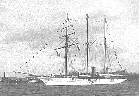
© by kind permission of The Library of Congress, Prints & Photographs Division
Thought to be the "S.Y. Clementine" - subject to confirmation
| Source Publications: |
| "Shipwrecks
of the Ulster Coast" | by | Ian Wilson |
| Impact Printing 1997 - ISBN: 0948154993 |
| Other Sources: |
| Royal
Navy |
- | Hydrographic Department (1970) |
| Randal
Armstrong | - | Castlereagh SAC (1980) |
| Michael
Montgomery | - | Castlereagh SAC (2006) |
| |
Last update - 08-Jun-2006
|
|
A page from "www.irishwrecksonline.net" ©